Location: Pokoteke Gorge
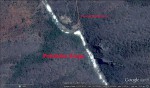
Photo: Google Earth
Satellite map Pokoteke Gorge
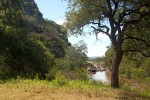
Photo: Bart Wursten
Entrance to Pokoteke Gorge
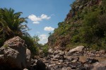
Photo: Bart Wursten
Large boulders and steep cliffs in the gorge
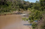
Photo: Bart Wursten
Pokoteke river
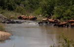
Photo: Bart Wursten
Cattle drinking at the river near the gorge
General Information
Quarter degree square: 2031A1 Country: Zimbabwe Habitat: Aquatic habitats, riverine vegetation and rocky slopes Altitude range: 1050 m in gorge; rising to over 1300 m on surrounding hills Annual rainfall: Location (short): Location (detailed): The Pokoteke Gorge lies to the north of Lake Mutirikwi (Kyle) and is formed where the Pokoteke River cuts though the Beza Range of hills on the northern side of the Lake. |
Description
The Gorge runs from NW to SE and the SE end lies within Lake Kyle Recreational Park (our location no. 75).
A path runs alongside the Pokoteke River though the gorge. Many riverine species may be found as well as plants of rocky places and rock faces.
Useful links
View a list of records for Pokoteke Gorge
View a list of unique taxa (excluding cultivated plants) for Pokoteke Gorge
View a list of unique taxa (all taxa whether cultivated or not) for Pokoteke Gorge