Location: Mt Gorongosa
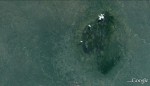
Photo: Google Earth
Satellite image Mt Gorongosa
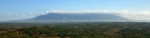
Photo: Bart Wursten
Panorama Mt Gorongosa from the Southeast.
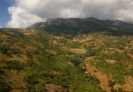
Photo: Bart Wursten
Mt Gorongsa from the drier northern slopes
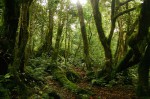
Photo: Bart Wursten
Tricholadus ellipticus mist forest on the higher slopes
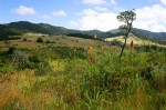
Photo: Bart Wursten
Kniphofia splendida in the upper Nhandar Valley
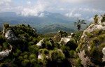
Photo: Bart Wursten
A view from Nhandore Peak
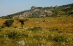
Photo: Bart Wursten
One of the upper plateaus with montane grassland and bogs.
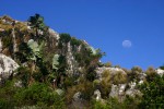
Photo: Bart Wursten
Moon rising over rocky upper reaches with Strelitzia and ericoid scrub
General Information
Quarter degree square: 1834A3 Country: Mozambique Habitat: Submontane and montane evergreen forests, ericoid vegetation, montane grasslands and bogs and many rocky outctops Altitude range: c.1000 - 1853m Annual rainfall: Location (short): Large isolated mountain plateau on the cental Mozambique coastal plain with peaks rising up to 1853m Location (detailed): |
Description
Useful links
View a list of records for Mt Gorongosa
View a list of unique taxa (excluding cultivated plants) for Mt Gorongosa
View a list of unique taxa (all taxa whether cultivated or not) for Mt Gorongosa