Location: Hillside Dams, Bulawayo

Photo: Bart Wursten
Aeollanthus rehmannii on rock plateau.
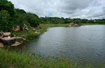
Photo: Bart Wursten
Hillside Dam.
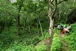
Photo: Bart Wursten
Old succulent gardens, now shaded by trees and overgrown with weeds.
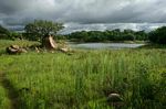
Photo: Bart Wursten
Abundant weeds colonizing dry edges of the Dam.
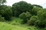
Photo: Bart Wursten
Dense woodland below the (upper) dam wall.
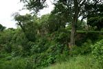
Photo: Bart Wursten
Old pavilion near the dam wall.
General Information
Quarter degree square: 2028B1 Country: Zimbabwe Habitat: Woodland, rocky outcrops, disturbed areas, colonising dam-edge vegetation. Altitude range: c. 1400 m Annual rainfall: Location (short): Location (detailed): |
Description
The following information has been provided by Hillside Dams Association.
Introduction
Syenite is the dominant rock in the area. This coarse reddish igneous material is about 2172 million million years ago. The overlying soils are acidic and sandy while the topography consists of open plains with broken kopjes and scattered boulders, a scenic asset and an ideal place for children to roam and explore.
The natural woodland vegetation is dominated by Terminalia, Acacia, Burkea, Sclerocara and Peltaphorum with a greater variety of species amongst the rocks or along the streams.
The park is also a proclaimed bird sanctuary and its diversity of habitats means that there are many species present. Unfortunately there are very few wild animals at present, although we have had offers to assist in restocking if we can provide an adequate and secure infrastructure.
Human History
On the property there are several nationally important archaeological sites. It was here that one of the earliest collections of Stone Age tools was gathered while there have been small archaeological excavations in some of the rock shelters.
One panel of rock paintings has been located and there are reports of others. Various early Farming Communities have built villages in the area. A particularly large site near the Upper Dam was partially excavated in the late 1960s and was extremely important in developing our current understanding of the Leopard's Kopje Tradition (10th to 13th Centuries) and was associated in someway with the important site of Mapungubwe near the Shashe-Limpopo confluence.
In the 19th Century it was the site of one of King Lobengula Khumalo's favourite outlying village to which he could escape the daily routine and strains of life at koBulawayo (Old Bulawayo), the state's capital. This was Matsheumhlope or White Stones. Said to be an hour and a half's gallop from koBulawayo through plains, rocky kopjes and reed-infested marshes, it was a retreat where the monarch would entertain many of his more trusted visitors.
In 1895 several of the leading Rhodesian settlers started work on the country's first commercial water supply, building the original Hillside Dams. The first three structures took some time to build and were only completed by January 1898. The London-based firm then waited with bated breath as they slowly filled. All was going well until on January 10th 1898 the upper two dams collapsed, unable to cope with the force of inflow. The remaining lower wall and one of the upper ones were rebuilt to higher standards. These structures are the cores of the existing two walls. Later in 1924 the Hillside Dams and all the associated water reticulation facilities were sold to Bulawayo Town Council. Soon after the dams were decommissioned in favour of better sources elsewhere, namely Khami (1927) and Ncema (1943).
As an aside when the Upper Dam was being raised in 1915, the contractors uncovered a rich, limey deposit that contained many wild animal bones. Thought to be the 'kitchen waste' of earlier inhabitants it was investigated by Mr Zealley of the Geological Survey Department. Some of his conclusions are suspect but unfortunately the bones have been lost. We are always on the lookout to find another similar treasure trove.
Thereafter the area became a prime residential area while the strip of land adjacent to the dams was declared the country's first bird sanctuary. In 1942 it was declared a National Monument (number 34), a status it retains although no one is exactly sure of the actual boundaries of the proclamation which may in fact have covered much of the adjacent residential suburbs.
Various attempts have been made over the years to develop the area but these have not been sustained. There was a flurry of work in the late 1950s following the recommendations of an international parks consultant, Professor RH Compton. At the time the main roads and paths were formalized and the tearoom at the lower dams was erected. One of the key developments was the creation of the Aloe Garden in the 1960s building on a sizeable collection of over 1500 aloes donated by Cram Cooke who worked in the National Museum.
In the 1990s there was a marked deterioration with vandalism and poor security. Few people would dare to go to 'The Dams'. This is the reason for the current initiative, we citizens of Bulawayo need to take back what was once ours making it again a safe venue to relax, meet and for children to play.
General description
The Hillside Dams, once the principle source of Bulawayo's water supply, are in easy reach of the centre of town. Although distinct from the Matopo Hills, this area of broken kopjes and sandy open plains resembles the much larger, better-known World Heritage site. Its natural vegetation is still largely intact and includes a wide range of indigenous species while the bird life is diverse.
The area has attracted people since the earliest of times. There are several examples of rock paintings as well as settlements dating from the Middle Stone Age (about 200 to 40 thousand years ago) to a large village contemporary with the Mapungubwe State of the Shashe-Limpopo confluence (AD 1000 to 1200). It was also the location of King Lobengula Khumalo's favorite royal village to which he escaped when the stresses and strains of power at the nearby capital of koBulawayo were too great. More recently it has catered for generations of Bulawayo residents seeking an accessible place of refuge and winding down.
Unfortunately the area has been allowed to deteriorate reflecting the severe lack of capital resources of the Bulawayo City Council. Compounding this was a series of muggings and a murder of a tourist which meant that most people shunned this once popular location.
We would like to alter this. As a community-oriented project the area (86 ha.) has been leased by a group of local residents with the aim of restoring it. It should again be one of the prime recreational venues in Bulawayo, enjoyed by all of its residents. In addition several educational projects are envisaged. These will focus on both natural and cultural heritage, with a commoner Ndebele village and a schools' nature trail key components.
We are currently initiating renovation existing facilities and drawing up plans for the new projects. Security and the need to fence the area, as well as beefing up the number and equipment of our security guards are urgent priorities. However it is no an easy thing in the current circumstances in Zimbabwe. Those interested in seeing what we are planning and to keep updated on the project can visit the Hillside Dams website or contact Rob Burrett by email.
Useful links
View a list of records for Hillside Dams, Bulawayo
View a list of unique taxa (excluding cultivated plants) for Hillside Dams, Bulawayo
View a list of unique taxa (all taxa whether cultivated or not) for Hillside Dams, Bulawayo